Cumberland Site (18CV171)
Introduction
The Cumberland Site (18CV171) is a palisaded Late Woodland village located on a bluff overlooking the Patuxent
River in Calvert County, Maryland. A portion of the site, including the palisade, has been radiocarbon
dated to the 16th century, and the site also contains evidence of earlier occupations as well as
some evidence for occupation at the turn of the 17th century. The Cumberland Site is only the second
palisaded settlement found in Tidewater Maryland, and the first found on the Patuxent River. During the
Late Woodland and Contact Periods, the Patuxent region appears to have been a battleground between the
Chesapeake Algonquian-speaking groups and the Susquehannocks to the north. It is possible although
not confirmed that the Cumberland Site and the town of Opament recorded on Captain John Smith's
Map of Virginia (published in 1612) are one and the same.
The site's inhabitants were able to grow corn and other domesticated crops, fish, and harvest oysters
at a location that gave them strategic views up and down the Patuxent River.
Archaeological Investigations
The Cumberland Site was discovered by Richard Stearns in the 1930s. The survey of the site was cursory,
focused on locating and mapping shell middens, and included no subsurface investigation. No
evidence of a palisade was recorded at this time (Williams 1983).
In 1982, the Cumberland family notified the Maryland Historical Trust (MHT) that they were
planning to construct a house on a portion of the site. In May of that year, Michael Smolek
from MHT's Southern Maryland Regional Center conducted initial investigations to determine the
site's subsurface integrity. Smolek first performed a quick controlled surface collection,
collecting artifacts from 49 20-by-20 meter squares and 19 partial 20-by-20 meter squares across an
agricultural field. To check for subsurface remains, 30 shovel test pits were excavated along
two transects. One shovel test pit revealed a section of the palisade. Smolek then traced 76
meters of the palisade line using 15 random test units of various sizes.
In May 1983, the site was divided into 400 4-by-4 meter squares and artifacts were surface collected
from 276 of these units. All artifacts were retained, except for oyster shell, fire-cracked rock,
and non-cultural rocks, which were weighed and discarded. Soil samples were also taken a few
centimeters below the ground surface from each of the 276 collected squares. A third surface collection,
using the same grid and collection procedures, was conducted in June 1983 after the site had been plowed.
Unfortunately, the southeastern portion of the site had been bulldozed, so this area could not be
collected. Oyster shell was neither retained nor weighed during this investigation.
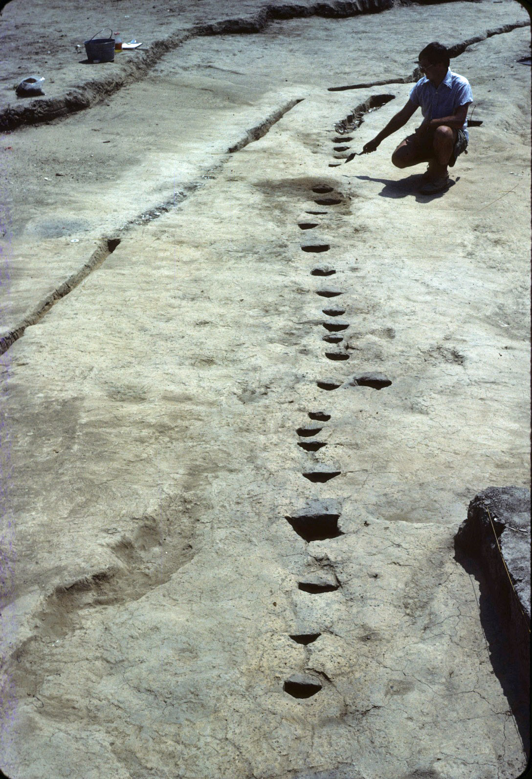 Palisade
Forty-two systematically and 42 randomly placed test squares, each measuring 2-by-2 meters, were
excavated to subsoil across the site. All soil was dry-screened through 3/8-inch mesh, and
all oyster shell was quantified by weight and discarded. A Gradall was then used to mechanically
remove the plow zone on the portion of the site to be impacted by house construction, an area
measuring approximately 24 by 48 meters in size. All soil from features, including the palisade,
borrow pits, post holes, and hearths, was dry screened through 3/8-inch mesh or wet screened
through 1/16-inch mesh. The relative lack of features, such as postholes and pits, is probably
the result of the land having been plowed for a number of years, while clusters of artifacts
outside the palisade may represent additional settlement or activity areas.
The use of the Gradall allowed the archaeologists to define approximately 96 meters of the palisade line,
which formed the shape of an arc. Inside the palisade, only twenty post molds were found; the
archaeologists explained the absence of post molds with the site's long-term plowing. The Gradall
also revealed the presence of about 44 meters of filled ditch, which contained most of the site's in
situ artifacts. Soil collected from this and other features was wet-screened using 1/16-inch mesh,
and excavators collected a 20 percent soil and shell samples.
Artifacts
A total of 86,935 artifacts were recovered from the Cumberland Site, not including the materials
from the surface collection and shovel test pits excavated in 1982. All artifacts appear to date before
European contact, as no European trade material was recovered.
Ceramic objects recovered from the Cumberland Site included 5,593 ceramic fragments and nine
red clay tobacco pipe fragments. While many ceramic fragments could not be formally typed, 2,659
Townsend Series sherds and 119 Mockley sherds were identified. Over 4,900 fragments exhibit
no surface treatment, while 268 are fabric-impressed, 42 net-impressed, 34 cord-marked,
nine smoothed-over cord-marked, five smoothed, and two incised (575 fragments are unidentifiable).
Rim sherds revealed that the Late Woodland ceramic vessels from Cumberland were predominantly
straight-walled vessels with plain rims, as seen in the almost completely mended vessel from
Lot 534. In addition, one sand-tempered fragment with a hole drilled in its center might represent
a ceramic ornament. The nine red clay tobacco pipe fragments included two incised bowl fragments,
one punctated stem fragment, two undecorated bowl fragments, and four undecorated stem fragments.
A total of 4,206 lithic artifacts were recovered, with quartz, quartzite, chert, sandstone,
and rhyolite the predominant materials. Fifty-nine projectile points and point fragments were
found, including one St. Albans, one Morrow Mountain, two Bare Island, one Orient Fishtail,
one Jack's Reef Pentagonal, one Madison, six Levanna, seven Potomac, and 39 unidentifiable.
These range in date from the Early Archaic to the Late Woodland, but all triangular projectile
points were recovered from within the palisade. Twenty-five bifaces, two scrapers, one spokeshave,
and five hammerstones were also recovered.
Faunal materials were well represented at Cumberland, with 64,842 oyster shell fragments making up
the majority of the 66,433 faunal items recovered. Most of the harvested oysters appeared to have
been between three and four years of age, collected from clear water near the shore, and indicate
a fall and spring occupation at the site. Snail, clam, periwinkle, mussel, and unidentified shells
were also recovered in limited quantities. A barrel-shaped shell bead was the only worked shell
item recovered during excavations, while a shark's tooth, probably worn as a pendant, was recovered
from the plow zone. Soil acidity and mechanical destruction resulted in a relative lack of animal
bones in the plow zone at Cumberland. The 811 animal bones, including teeth, bones, fish scales,
turtle shells, and antlers, were recovered primarily from subsurface features.
References
Jefferson Patterson Park and Museum. n.d. Cumberland Finding Aid. In Archaeological
Collections in Maryland, online archives on the Jefferson Patterson Park and
Museum web site. Available at http://www.jefpat.org/NEHWeb/18CV171-%20Cumberland%20Finding%20Aid.aspx.
Smolek, Michael A. 1986 The Cumberland Palisaded Village
Site: A (Very) Preliminary Report. Paper presented at the Annual Meeting of
the Archaeological Society of Maryland.
Williams, M. Christopher. 1983. A Preliminary Site Report for the
Cumberland Palisaded Village Site, Calvert County, Maryland. Report submitted to
the Maryland Historical Trust, Southern Maryland Regional Preservation Center, and
American University.
What You Need To Know To Use This Collection
The database includes artifacts recovered from 767 contexts. These include artifacts from the surface
collections conducted in May 1983 and again in June 1983. Contexts from the same units can
conceivably be combined.
Plow zone units were labeled using a system similar to that used at Historic St. Mary's City. Four-by-4-meter
test units were assigned numerical designations, and the unit was then divided into four 2-by-2-meter quads with each
quad assigned an alphabetical label, including A, B, C, or D. Features and layers within features were also assigned
alphabetical levels.
Further Information About the Collection
For more information on the Cumberland Palisaded Village and collection access,
contact Rebecca Morehouse, Collections Manager, at 410-586-8583; email
rebecca.morehouse@maryland.gov
To Download Data
Data and a variety of other resources from this site are available for download. To download data,
please go to the Downloads page.