His Lordship's Favor (18CH793)
Introduction
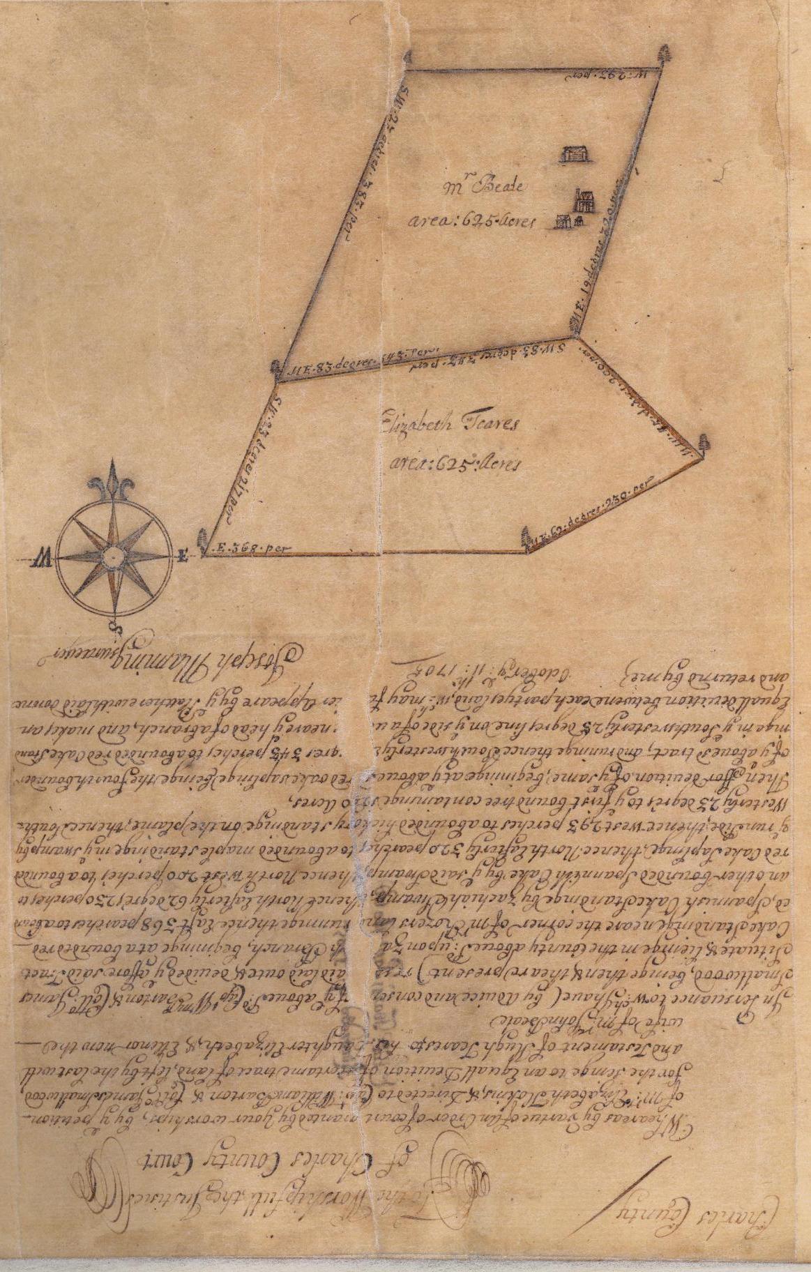 1705 plat, His Lordship's Favor (St. Mary's College of Maryland)
His Lordship's Favor (18CH793) is an enigmatic colonial site that was occupied by 1705 and
possibly earlier and abandoned ca. 1740. His Lordship's Favor is located on Zekiah Manor
deep in the interior of Charles County, Maryland, some 20 miles north of navigable water
along Piney Branch, near modern-day Waldorf. His Lordship's Favor is located near
Zekiah Fort, the fortified Piscataway Indian settlement
occupied from ca. 1680-1692.
Zekiah Manor was originally created in 1667 and was one of two proprietary manors in Charles
County. In 1672, Governor Charles Calvert, the eldest son of Cecil Calvert, the second Lord
Baltimore and Maryland proprietor, informed his father that he was in the process of building
a "country house for summer time" at Zekiah Manor. Calvert later told his father that building
in Maryland was "very Chargeable" and that the house at Zekiah Manor was built "according to
the fashion of the building of this Country," presumably in wood. "Zekiah House," as the summer
house was referred to on at least one occasion, has not been identified, although there is a
possibility that His Lordship's Favor may somehow be associated with or related to Calvert's
summer house.
His Lordship's Favor was a 1,250-acre tract that was later carved out of Zekiah Manor. The
name could suggest that this portion was a favorite of the proprietor and may be a clue that the
summer house was indeed located on this tract; it could also indicate a favor to the grantee. His Lordship's Favor was conveyed on August 20,
1699 by Charles Calvert, now the third Lord Baltimore and living in England, to William Boarman,
a long-time friend of Calvert's. Within two weeks, on September 2, Boarman transferred the property
to Hugh Teares. Teares, who did not reside on the property, was dead by January 1700. In June, his
widow, Eleanor, married John Beale. Teares' daughter by his first wife, Elizabeth, a minor, went to
live with an aunt, probably at Johnsontown.
In 1705, Elizabeth reached the age at which she was to receive her inheritance, and her aunt
requested a survey of His Lordship's Favor to begin that process. The resulting plat shows
the division of the property into two parcels of 625 acres each. The northern parcel went to
John Beale, Eleanor Beale's husband, while the southern parcel went to Elizabeth.
The plat prepared in 1705 depicts the property's bounds and shows four structures in some detail
on the portion inherited by Eleanor Beale and her husband, John. These buildings are described
in more detail, below.
In 1724, John Beale sold the couple's portion to his son, Richard Beale. Beale
immediately sold 300 of his 625 acres to William Middleton, who had married
Elizabeth Teares. This portion included the buildings shown on the 1705 plat. In 1738,
Middleton sold 450 acres of His Lordship's Favor, including the portion with the buildings,
to John Lancaster. Archaeological evidence suggests that the buildings were abandoned
shortly after Lancaster's acquisition of the property.
The Buildings Depicted on the 1705 Plat
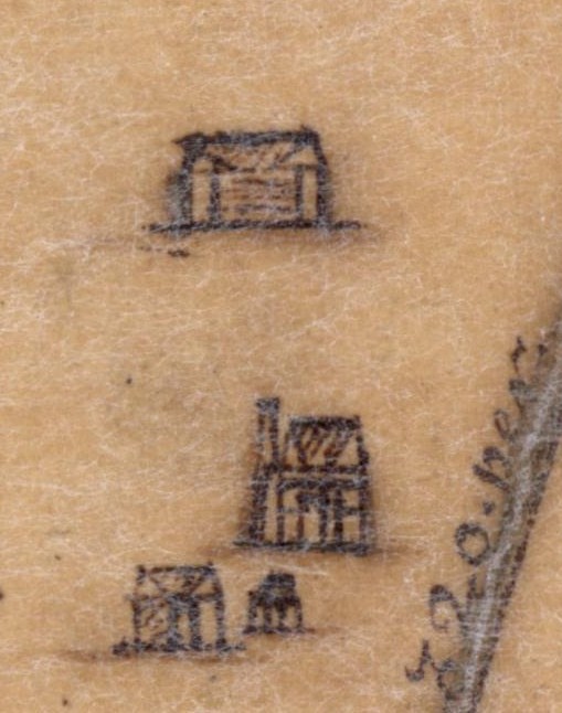 Close-up of buildings, His Lordship's Favor plat (St. Mary's College of Maryland)
The plat of His Lordship's Favor was created by surveyor Joseph Manning, who was also
the surveyor enlisted in 1697 to prepare a survey of the Courthouse at Moore's Lodge.
His renderings of the buildings at Moore's Lodge are remarkably detailed and accurate and the
archaeological investigations at His Lordship's Favor suggest a similar accuracy.
Architectural historian Cary Carson was asked to give his opinions about the buildings
shown on the 1705 plat. Carson concluded that he had little to say about the presumed
one-room farmhouse with a single end chimney. The nearby smaller structures, he found,
made sense as service buildings. The larger building was probably
…not a kitchen given the lack of chimneys, something that the surveyor was careful
to include in his rendering of outbuildings on the 1697 [court house] plat. The way he drew
the smallest structure [on the 1705 plat] with flared tops to the two interior posts raises
in my mind the possibility that he might be illustrating some kind of open sided shelter
with up-braces to the plates. But this is only conjecture.
With regard to the larger structure shown at the north end of the complex, Carson notes:
It was a long, rectangular structure with a pitched roof. There were no chimneys,
not on the gable ends and not internally. At first I was tempted to interpret the faint
horizontal lines across the facade as a representation of brick walling, especially in
view of the very different treatment Manning gave to the fronts of the other buildings.
It seemed possible to me that he was deliberately suggesting different materials. And
that may be true. On the other hand, when he rendered the Charles County courthouse
eight years earlier, he used horizontal lines to face a structure that we know was
not made of brick. Presumably there they stood for clapboards, or alternatively were
simply his convention for denoting the most important building in a group of structures.
Carson also noted that
…it was often Manning's practice to show one or both gables in elevation.
Distortion though this was, Manning was always careful to stand the triangular shape
of the roof directly above the gable, except in his depiction of the [larger service
building]. Here, he has consistently shown the front slope of the roof projecting forward
beyond the gable. Does this imply that there was a roofed porch across the front? Not
likely in 1705. We don't look for piazzas for another 50 years… As yet, I have no
plausible explanation for an overhanging front slope on a turn-of-the (18th-) century
structure.
Carson does not note it, but the large building also does not appear to have windows.
This has led some researchers to suggest that this building may have functioned as a
tobacco house for curing tobacco. As a tobacco house, the building as depicted is larger
than would be expected. Archaeologist Garry Stone has argued that tobacco houses rarely
exceeded 20 by 40 feet in dimension because of the labor requirements for bringing
newly-cut, heavy tobacco to the curing shed. The larger the barn, the greater the distance
the heavy tobacco would need to be carried. In addition, households were able to
produce only so much tobacco because of the labor requirements for cultivation; an
excessively large barn would potentially be that much wasted space. Nonetheless, the
possibility that this large building was a tobacco barn cannot be dismissed without
further evidence.
The structures depicted on the 1705 plat and the archaeological evidence recovered from
His Lordship's Favor indicate a well-developed complex with a well-appointed dwelling.
The presence of a brick chimney, at least one glazed window, and a number of architectural
spaces in the form of outbuildings would be unexpected for a tenant or servant/slave
household. These architectural amenities are typically (although not always) associated
with a landowning planter rather than with a tenant or a servant, especially at such an
early date.
As the evidence suggests, someone had invested fairly substantially in the dwelling house.
Brick construction was limited in early Maryland, although probably not as much as initially
concluded by Cary Carson and his colleagues in 1981 (Carson et al. 1981; King and Chaney 1999).
Nonetheless, planters could make more money investing scarce labor resources in the production
of tobacco than in the manufacture of brick. In a study of room-by-room probate inventories
from Maryland and the architectural spaces available for domestic activities in the households
represented by these inventories, historian Gloria Main (1982:152-153) found that, between 1660
and 1719, inventories listing five or more spaces belonged to decedents worth about 150 pounds
sterling or more at their death. These individuals were in what Main identified as the upper
third of wealth holders.
Archaeological Investigations
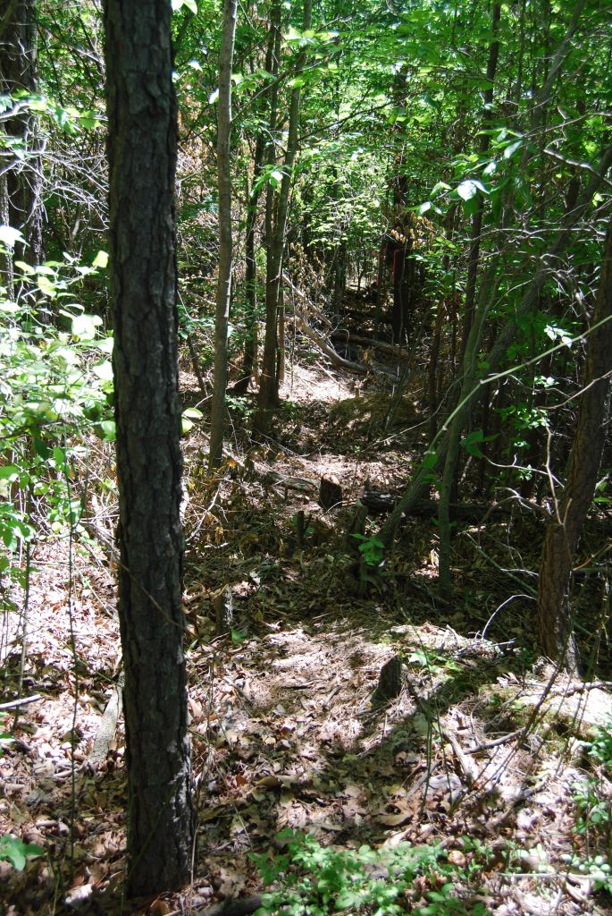 Shovel test transect, His Lordship's Favor (St. Mary's College of Maryland)
Archaeological investigations were undertaken at His Lordship's Favor in May 2009 by
archaeologists from St. Mary's College of Maryland under the direction of Julia A. King. The grid established at the site
follows Maryland State Plane. A total of 224 shovel tests and three 5-by-5 foot test units
were excavated in the area where the plat depicts the buildings (archaeological evidence
suggests that the buildings represented on the plat did in fact exist). Soils from each
shovel test and from each test unit were screened through ¼-inch hardware cloth. Measurements
at the site were made in feet and tenths of feet.
The stratigraphy at His Lordship's Favor consists of a plow zone overlying subsoil. Plow zone
is predominantly a brown to dark brown clayey to sandy clay loam ranging in depth from five to
eight inches. In most cases, plow zone overlies a subsoil consisting of a yellowish brown to
brown sandy clay. The gravel content of the subsoil varies significantly across the project area.
The features exposed in the three test units were identified as either subsoil variants or root
molds with one exception. The exception was a roughly circular intrusion measuring less than a
foot in diameter. Features were mapped but not excavated.
Artifacts
A total of 1,343 artifacts were recovered from His Lordship's Favor; fully 73.7 percent of these
materials consist of brick (n=919) and daub (n=71). Unidentified iron artifacts, or objects too
corroded to identify, form 5.9 percent of the collection (n=79).
In addition to the brick and daub, other architectural materials recovered from His Lordship's
Favor include four nails and 115 nail fragments. The four whole nails measured 1.44 inches,
1.88 inches, 2.25 inches, and 2.38 inches in length. Seven fragments of window glass and a
single window lead fragment (with the piece of glass still intact) were also recovered.
Eighteen of the 28 tobacco pipe fragments recovered from His Lordship's Favor have
measurable stem bore diameters, all measuring either 4- or 5/64ths-inch. This
distribution points to a first half of the 18th-century date.
The 42 ceramic fragments also point to an early 18th-century date with some qualification.
In addition to tin-glazed and unidentified lead-glazed earthenwares, the ceramic assemblage
includes Staffordshire slipwares, English Brown stonewares, dipped white-salt-glazed
stonewares, and white salt-glazed stonewares.
A single fragment of Rhenish brown stoneware and four Native-made ceramics, including three
Potomac Creek fragments and an unidentified fragment with a plain surface, could suggest a
pre-1700 occupation. Not a single fragment of Rhenish brown stoneware was recovered from the
nearby Zekiah Fort site, which was first occupied ca. 1680. It is possible that the Rhenish
brown ceramic recovered from His Lordship's Favor represents a curated vessel. The Potomac
Creek ceramics could also suggest that a Native household remained in the area after 1692
when Zekiah Fort was abandoned.
Of the 17 fragments of bottle glass believed to be colonial in date, one derives from a case bottle.
Artifacts of note include an iron mattock, a possible drawknife fragment also of iron, a silver one-quarter
two-reales Spanish coin, and two copper alloy tacks.
References
Brown, Anne S. 1965. Charles Calvert's House in the Manor of Zekiah, Charles County, Md. Privately printed.
Carson, Cary. 2008. Electronic correspondence with Julia A. King. On file, Zekiah Project Records, St.
Mary's College of Maryland, St. Mary's City.
Cary Carson, Norman F. Barka, William M. Kelso, Garry Wheeler Stone, and Dell Upton. 1981.
Impermanent Architecture in the Southern American Colonies. Winterthur Portfolio 16(2/3): 135-196.
King, Julia A. and Scott M. Strickland. 2009. In
Search of Zekiah Manor: Archaeological Investigations at
His Lordship's Favor. Report prepared for the Citizens of Charles County. St. Mary's City: St. Mary's College
of Maryland.
King, Julia A. and Edward E. Chaney. 1999. Lord Baltimore and the Meaning of Brick
Architecture in 17th-Century Maryland. In Old and New Worlds: Historical/Post Medieval Archaeology
Papers from the Societies' joint conferences at Williamsburg and London 1997 to mark thirty
years of work and achievement, edited by Geoff Egan and R.L. Michael. Oxbow Books,
Oxford, England.
King, Julia A., Scott M. Strickland, and Kevin Norris.
2008. The Search
for the Court House at Moore's Lodge: Charles County's First County Seat. Report prepared
for the Citizens of Charles County. St. Mary's City: St. Mary's College of Maryland.
Main, Gloria L. 1982. Tobacco Colony: Life in Early Maryland, 1650-1720. Princeton, Princeton
University Press.
Maryland Historical Society. 1889. The Calvert Papers. Volume I. Baltimore, John Murphy and Company.
Stone, Garry Wheeler. 1982. Society, Housing, and Architecture in Early Maryland: John Lewger's St. John's.
Unpublished Ph.D. dissertation, Department of American Civilization, University of Pennsylvania, Philadelphia.
What You Need To Know To Use This Collection
- Measurements were made in feet and tenths of feet.
- All soils were screened through 1/4-inch mesh.
- The site grid is aligned with Maryland State Plans.
- The deposits consist of 224 shovel tests and three 5-by-5-foot test units.
Further Information About the Collection
The His Lordship's Favor collection is owned by State of Maryland and curated by the Maryland Archaeological
Conservation Laboratory. For more information about the collection and collection access, contact
Rebecca Morehouse, Collections Manager, at 410-586-8583; email
rebecca.morehouse@maryland.gov.
To Download Data
Data and a variety of other resources from this site are available for download. To download data,
please go to the Downloads page.