Posey (18CH281)
Introduction
The Posey Site (18CH281) is located near Mattawoman Creek in Charles County,
Maryland, aboard what is now the Naval Surface Warfare Center–Indian
Head Division. The site was initially identified in 1963 by Navy chemist
Calvert Posey in an area that had been damaged by an earlier explosion
at Indian Head’s Biazzi Nitration Plant, where nitroglycerin was manufactured.
In 1985, the site was tested by William Barse as part of a much larger
archaeological survey of the Indian Head facility. The site was investigated
more extensively in 1996 by staff from Jefferson Patterson Park and Museum,
under the direction of Julia A. King and Edward E. Chaney.
Artifacts recovered from the Posey Site indicate the presence of a small,
single-occupation component, probably Native American, dating to the period
between 1650 and 1700, although the exact size of the original settlement
is uncertain because portions of the site were destroyed by later construction.
Systematic shovel testing around the site suggests that, unlike the
Camden Site (44CE3) on the south side of the
Rappahannock River, the Posey Site was a relatively isolated domestic settlement,
although other Native American occupations are no doubt present in the area along
Mattawoman Creek that was reserved for Indian use in the 17th century.
Historical research suggests that the Indians living at Posey were likely
Mattawoman, a component group of the Piscataway
Indians. The land containing the site had been granted by Lord Baltimore
to Thomas Cornwallis in 1636, and was re-patented by Cornwallis in 1654,
although there is no evidence any Europeans were living in the area by
that time. In October 1665, Nancotamon, one of the great men of Mattawoman,
came before the Maryland Provincial Council and asked what his people should
do, whether they should “remove further into the woods or to remayne upon
the land where they now or lately lived,” presumably in this portion of
Charles County. In response, the Council ordered the metes
and bounds of the “ould habitations” of the Mattawoman surveyed,
and, in the interest of peace and safety, forbade any Englishman from taking
up lands within those boundaries. The Council further declared that any
Englishman so settling risked imprisonment.
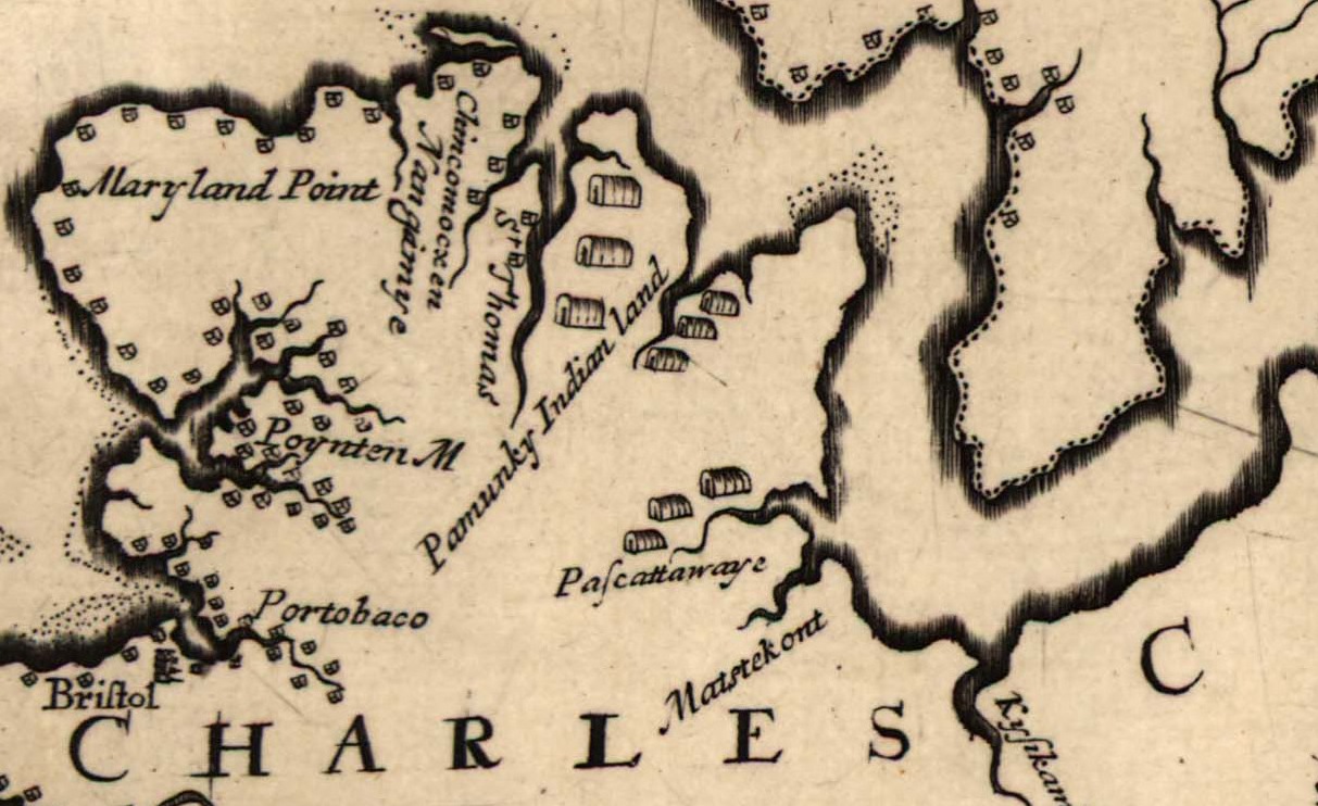 Portion of Hermann map
For the next several years, the English government worked toward protecting
Indigenous lands in this area. In particular, the Provincial Council forbade
settlement between the heads of Mattawoman and Piscataway creeks until
portions of the lands had been officially allotted to the Mattawoman. Significantly,
this is the area including the Posey site. Augustine Herman’s map of Maryland
and Virginia, which was completed in 1670 and published in 1673, shows three longhouse
structures in the vicinity, although not in the exact location of the Posey
site. Significantly, Herman’s map also shows encroaching English settlements
on the south side of Mattawoman Creek. Researchers have cautioned that
Herman’s map, while impressively accurate, should not be taken literally.
Still, the map does suggest English settlement very nearby at the end of
the third quarter of the 17th century.
Following Cornwallis’ death in the late 1670s, his land was willed to his
wife, Penelope. The widow Cornwallis sold Mattawoman Neck in 1688 to Captain
Edward Pye. One of the instruments of transfer recognizes that the land
was “now in possession of Indians.” Although twenty-five years previously
the Provincial Council had made concerted efforts to protect Indigenous settlements
in this area, such issues do not seem to have been a concern when Pye acquired
the land. Nonetheless, the Indians living on the tract may have been left
alone, at least for a while. In 1695, the colonial government pondered
how it might convince Indigenous people living in that area to allow some English
settlement, thereby increasing the production of tobacco.
It is about this time—the end of the 17th century—that the
Posey site appears to have been vacated.
Archaeological Investigations
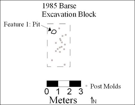 Barse excavation block.
Following the site’s discovery in 1963, Calvert Posey and his colleagues
excavated a large number of artifacts from it. They uncovered a number
of features, including house patterns and storage pits, at least some which
were apparently excavated. A brief report by Posey (n.d.) describes—without
quantifying—some of the artifacts he found, including Native and European
pottery, red and white clay pipes (including one he claims bore a 1618 date
mark), copper and stone triangular points, iron nails, lead shot, shell
beads, and large amounts of wild animal bone. No field maps or notes on
this work are known to exist. The collections from this effort remain in the
possession of the Posey heirs.
In 1985, William Barse excavated a total of 11.5 square meters, including a block
excavation measuring 4 by 2 meters and three additional units. At the base
of plow zone in the block excavation, Barse recorded 17 features, including
16 post molds and a small pit. Several features were tested. Barse concluded
that the Posey Site was first occupied by Indigenous people just prior to
the arrival of Europeans, and continued to be occupied for an unknown period
of time following the English settlement of Maryland. The overwhelming
majority of recovered artifacts included materials produced by Native Americans,
although a small amount of European material was also recovered. Barse
interpreted these European artifacts as trade goods.
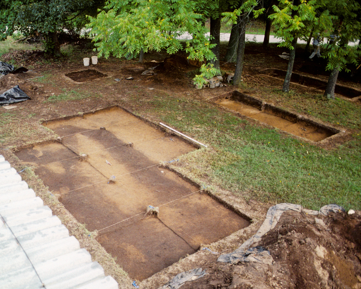 Excavation units and 1985 excavation block photographed facing northeast, showing possible filled ravine head
(Courtesy Naval Support Facility Indian Head, Naval District Washington)
Excavation units and 1985 excavation block photographed facing northeast, showing possible filled ravine head
(Courtesy Naval Support Facility Indian Head, Naval District Washington)
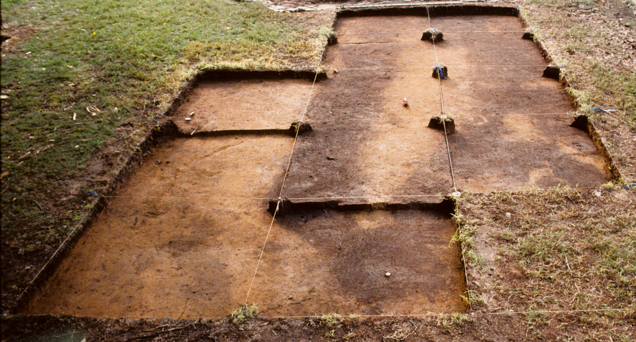 Excavation units photographed facing south showing amorphous
midden feature (Courtesy Naval Support Facility Indian Head, Naval District
Washington)
Excavation units photographed facing south showing amorphous
midden feature (Courtesy Naval Support Facility Indian Head, Naval District
Washington)
Julia King and Edward Chaney returned to the site in 1996 in an effort to identify the
spatial and chronological boundaries of the site as precisely as possible,
and to collect evidence useful for interpreting Indian lifeways in 17th-century
Maryland. A total of 510 shovel tests were excavated at intervals of eight
meters over an area measuring approximately 9.9 acres. Fill from the shovel
tests was screened through ¼-inch hardware cloth. Thirty-seven 1.5-by-1.5-meter
units were subsequently excavated within the boundaries of the site as
established by the shovel testing. The plow zone from these units was screened
through ¼-inch mesh. A 25-by-25-cm column sample was taken from
each unit and water-screened through fine mesh in an effort to recover
beads and other small artifacts and faunal remains.
Seven discrete features, including five post molds, a pit, and an unidentified
feature, along with one large midden deposit, were identified below the
plow zone. The post molds were mapped, sectioned, excavated, and the profiles
recorded, all suggesting posts driven into the surrounding subsoil. The
large midden feature was linear in places and amorphous in others, and
may represent the head of a ravine used to discard refuse. Eight sections
were excavated in an effort to document the feature’s shape, stratigraphy,
and artifact content. Most of these sections were water-screened, although
several samples were retained for flotation. The feature’s fill contained
a rich assemblage of cultural material, including artifacts of Indigenous and
European manufacture. The feature itself was relatively shallow (10 to
20 cm in depth) with a sloped, basin shaped bottom.
Louis Berger and Associates conducted additional testing at the site in 2012,
including the excavation of one test unit in the site core and 43 shovel tests
on the north side of Braggs Road, none of which were positive. Materials recovered
from the Berger work are not included in the database.
Artifacts
More than 11,000 materials, including artifacts, shell, and animal bone,
were recovered during the 1996 investigations, from both shovel tests and
excavation units. Slightly more than 1,500 objects are included in the
collection that were generated by the excavations undertaken by Barse in 1985. Among
these artifacts are Indigenous and European ceramics, red and white
clay tobacco pipe fragments, glass, lithic tools and debitage, nails and
other metal objects, bone, shell, and relatively large numbers of materials
apparently related to Navy construction activities and the Biazzi Plant
explosion.
Ceramics include nearly 3,000 fragments of Native-made ceramics, predominantly
Potomac Creek wares, although small amounts of Yeocomico, Camden, Moyoane,
and Accokeek ceramics are also present in the collection. More than
90 percent of the Potomac Creek fargments are of the plain variety, suggesting
a 17th-century date of manufacture. At least 47 Potomac Creek vessels are
represented in the collection. Wheel-thrown ceramics of European manufacture
number less than 70 fragments, represented primarily by tin-glazed earthenware.
Other European types present include Rhenish brown stoneware, Rhenish blue
and gray stoneware, black lead-glazed earthenware, and five fragments of Challis-like
earthenware.
Both Native-made and European white clay tobacco pipe fragments were recovered
from the site, although in small numbers when compared with contemporary
sites occupied by the Chesapeake English. All of the red tobacco
pipe fragments appear to derive from hand-made, Native-type smoking pipes.
Lithic artifacts include tools, debitage, and fire-cracked rock. Stone
types include quartz, quartzite, chert, rhyolite, and European flint. Indeed,
while quartz was the most common stone type at approximately 63 percent,
European flint formed 18 percent of the lithic assemblage. Much of this
flint consisted of debitage, although two gunflints and a cutting tool
were made of European flint.
Thirty-eight copper alloy fragments were recovered from the site, including
triangles, rolled cones, and scraps or fragments. At least one of these
triangles was clearly intended as a projectile point, made of two layers
of metal with a deep basal notch terminating in a round perforation near
the artifact’s center. The remaining five triangles were flat, and two
had perforations in their centers. They too may have functioned as points,
although an ornamental usage may also be suggested. Two copper alloy
cones were also recovered.
Lead or pewter artifacts include several pieces of shot, a hemispherical
button, and a tongue-shaped piece of lead sheet identified as possibly
a pad to help secure a gunflint within the lock of a musket or other firearm.
A small fragment of possible lead sprue and a small unidentified cylindrical
object were also recovered.
Iron artifacts include nails and nail fragments, a knife blade, a possible
furniture or architectural fragment, and numerous pieces of unidentified
iron. Seventy-nine wrought nails or nail fragments were recovered, all
in advanced stages of deterioration. Two nails appear to have been deliberately
clinched, which suggests that these artifacts had been driven into boards
and then bent or folded over for extra holding power and safety.
A buckle fragment of unidentified metal was also recovered.
Glass artifacts include colonial bottle fragments (including two nearly
complete case bottle kick-ups), three beads, and four buttons with remnant
metal shanks. One of these buttons has a white, star-shaped white glass
inlay on its upper surface, and is identical to buttons recovered from
the Burle's
Town Land Site (18AN826). A similar button is depicted in a
mid-16th-century portrait of an English woman, but it is unclear if the
button recovered from the Posey site was used by the site's occupants as a
clothing fastener.
Bone artifacts include fragments of a bone comb and a bone needle fragment.
The bone comb pieces come from the same object. A relatively large number
of tubular (peake) and disk (roanoke) shell beads were also recovered from
the site as a result of the effort to collect and water-screen column samples
from the plow zone. Several bead blanks provide evidence that shell beads
were probably being manufactured on site.
Although the animal bone recovered from the Posey Site was considerably
fragmented, and much of it had been recovered from plow- and Navy-disturbed
contexts, samples were submitted for zooarchaeological analysis. David Landon
fount that the assemblage contains a wide range of species representing many
of the resources in the rich environment of the Chesapeake Bay
estuary—fish, shellfish, aquatic and land turtles, terrestrial mammals
(especially deer), and semi-aquatic mammals. However, bird bones are absent
from the assemblage. When compared with faunal assemblages recovered from
pre-1600 Indigenous sites, the Posey site faunal assemblage is similar to
these collections—aquatic and terrestrial mammals, turtles, and fish,
but few birds. When compared with assemblages recovered from contemporary
sites occupied by the Chesapeake English, however, the differences are
striking. The only European domesticate in the assemblage consists of a few
small fragments of pig bone, an animal that could have been easily acquired
through trade or retaliation for crop damage.
Grace Brush of Johns Hopkins University collected and analyzed two soil
cores from Mattawoman Creek near the site. Both were as interesting for
what they did not reveal about the site as much as for what they suggested.
Both cores were dominated by pine and wetland species, and there was no
distinction between pre- and post-colonial vegetation, as has been seen
in other areas. There was no evidence of deforestation or other effects
on wetland species caused by European agricultural practices, even in the
later 18th, 19th, and 20th centuries. In part this may be due to the difficulty
of distinguishing ragweed from marsh elder pollen; still ragweed (or marsh
elder) pollen is present throughout these cores, the dates of which range
back to approximately the mid- to late 14th century.
References
Barse, William P. 1985. A Preliminary Archaeological
Reconnaissance Survey of the Naval Ordnance Station, Indian Head, Maryland,
Volume I: Cornwallis Neck, Bullitt Neck and Thoroughfare Island. Draft
report prepared for the Department of the Navy, Chesapeake Division, Naval
Facilities Command.
Brush, Grace S. 1997. Pollen Study of Two Sediment
Cores from Mattawoman Creek, Maryland. Prepared for the Department of Research,
Jefferson Patterson Park and Museum, St. Leonard.
Galke, Laura J. 2004. Perspectives on the Use of European
Material Culture at Two Mid-to-Late 17th-Century Native American Sites in the
Chesapeake. North American Archaeologist 25(1):91-113.
Harmon, James M. 1999. Archaeological Investigations
at the Posey Site (18CH281) and 18CH282, Indian Head Division, Naval Surface
Warfare Center, Charles County, Maryland. Draft manuscript on file, Maryland
Archaeological Conservation Laboratory, Jefferson Patterson Park and Museum,
St. Leonard.
Katz, Gregory, and Charles LeeDecker. 2012. Phase I Survey
for Riverwater Line Replacement at the Posey Site (18CH281), Naval Support
Facility Indian Head, Charles County, Maryland. Ms. on file,
Maryland Archaeological Conservation Laboratory, Jefferson Patterson Park
and Museum, St. Leonard.
Landon, David B., and Andrea Shapiro. 1998. Analysis
of Faunal Remains from the Posey Site (18CH281). Prepared for the Department
of Research, Maryland Archaeological Conservation Laboratory, Jefferson
Patterson Park and Museum, St. Leonard.
Posey, Calvert R., Sr. n.d. Matiwataquamend: An Indian
Village on the Indian Head Peninsula of the Mattawoman Creek. Ms. on file,
Maryland Archaeological Conservation Laboratory, Jefferson Patterson Park
and Museum, St. Leonard.
What You Need To Know To Use This Collection
- The Posey site was occupied from c. 1650 until 1690.
- The site was discovered during a chemical explosion.
- Excavations were undertaken at the site in 1985, 1966, and 2012.
- Efforts were made in 1996 to use the 1985 grid. No points were left behind
in 1985 so the grid fit is approximate.
- Materials from the 2012 excavations are not included in the database.
- Plow zone was recovered and screened through 1/4-inch mesh and window
screen.
Further Information About the Collection
The Posey Site archaeological collection is owned by the U.S. Navy and
curated by the Maryland Archaeological Conservation Laboratory. For more
information about the collection and collection access, contact Sara Rivers Cofield,
Federal Collections Manager, at 410-586-8589;
email Sara.Rivers-Cofield@md.gov.
To Download Data
Data and a variety of other resources from this site are available for download. To download data,
please go to the Downloads page.