Zekiah Fort (18CH808)
Introduction
The Zekiah Fort site (18CH808) contains the archaeological traces of a 17th-century fortified
Piscataway settlement located several miles south of Waldorf in Charles County, Maryland.
The Piscataways were a large and powerful nation located on the north shore of the Potomac,
tracing their leadership back to at least ca. 1300 AD. From that time until the early 17th century,
the Piscataways had maintained their principal settlement and capital on the south side of
Piscataway Creek at its confluence with the Potomac River. Sometime after 1600 AD they moved
their capital further up Piscataway Creek, where they continued for several decades following the
arrival of English settlers.
In 1680, during a period of significant unrest along the Maryland frontier, the Piscataways
were forced to seek refuge from raids by the Susquehannocks and other northern Indigenous groups. By
terms of a treaty signed in 1666, Charles Calvert, the Third Lord Baltimore, was obligated to
provide assistance to the tributary group. He directed them to Zekiah Manor, one of several manors in Maryland
held by Baltimore. The site is located on a later (ca. 1695) subdivision within the manor known as
"Jourdan" (or Jordan).
The raids the Piscataways were suffering were in part retaliation for their role supporting the
Marylanders in the 1675 siege of the Susquehannock Fort,
located at the mouth of Piscataway Creek not far from the Piscataways' ancestral settlement. This
siege, which was joined by a number of Virginians, precipitated Bacon's Rebellion in Virginia and
created considerable unrest in the two Chesapeake colonies. When the Piscataway were directed to
Zekiah, "a place now known unto them," they abandoned their corn and other crops and arrived in
a destitute situation. Archaeologists Dennis C. Curry and Maureen Kavanagh estimate that the group
seeking refuge consisted of between 90 and 300 members.
The Zekiah Fort site is found both at the top and at the base of a defensible knoll surrounded on
three sides by springs and creeks ultimately draining into Piney Branch. A perennial spring provided
freshwater for the people moved to the spot. An existing farm road probably follows the trace of the
original 17th-century path leading to the knoll's top. Extensive survey in the area (including shovel
testing of some 90 plus acres) suggests that the fortified settlement was confined to an area of
about five acres.
Archaeological and documentary evidence indicate that the Piscataway remained at Zekiah Fort for
about 12 years, although it also appears they periodically returned to their principal settlement
at Piscataway. They finally abandoned Zekiah Fort in 1692, the same year that Baltimore reached a
settlement with royal authorities after his government was overthrown in 1689. It is possible that
the Piscataways' departure was driven by Baltimore's settlement.
The fort's location appears to have remained in the local memory at least through the late 19th
century when a local man of "Wicomico" ancestry was reported to have taken visitors to the location.
The memory of the settlement's location, however, had been forgotten by the early 20th century.
Archaeological Investigations
 Post mold features, Zekiah Fort (St. Mary's College of Maryland)
The location of Zekiah Fort has been a focus of interest since at least 1934, with historians,
archaeologists, and members of the now state-recognized Piscataway Conoy Tribe of Maryland
interested in relocating the site. In 2009, Michael J. Sullivan, a local historian and businessman,
and his wife Laura sponsored a series of surveys in the effort to locate and preserve the site. Archaeologists
from St. Mary's College of Maryland under the direction of Julia A. King and Scott Strickland surveyed
a number of properties along Zekiah Run believed to have a high potential for containing evidence
of the fort. These efforts were rewarded in February 2011 when Potomac Creek ceramics, red and
white tobacco pipe fragments, and glass beads were discovered in shovel tests along an unnamed
tributary of Piney Branch.
The archaeologists had been drawn to the location's perennial freshwater stream, productive agricultural
soils, and defensive situation. The shovel testing program at the site included the excavation of 1,362
shovel tests. Fill from the shovel tests was screened through ¼-inch hardware cloth and all artifacts
were retained. Only 233 shovel tests yielded artifacts datable to the late 17th century; these shovel
tests were used to define the site's horizontal boundaries.
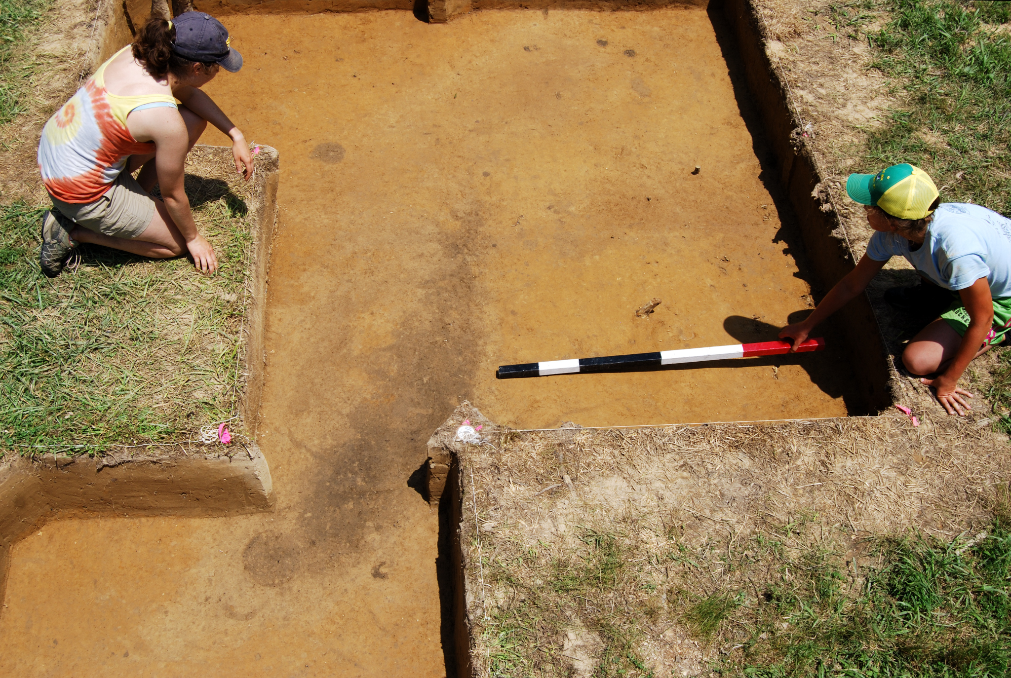
Following the shovel testing, 46 5-by-5 foot test units were excavated between May and July 2011 and an
additional 25 units were excavated between May and July 2014. The test units along with the shovel tests
were aligned with Maryland State Plane. The soil removed from each test unit was screened through ¼-inch
hardware cloth. In an effort to recover beads and other artifacts of small size, a one-cubic foot column
sample of the plow zone from each test unit was collected, screened through ¼-inch mesh, and the
remaining soil then water-screened through fine mesh. All artifacts were retained.
 Possible post mold and hearth features (Unit 445285), Zekiah Fort (St. Mary's College of Maryland)
The site has been extensively plowed. On the knoll top, stratigraphy at the site consists of a dark
yellowish brown plow zone overlying a yellowish brown subsoil. Plow zone in this area ranged from
0.53 to 1.78 feet in depth, with an average thickness of 0.91 foot across the top of the knoll.
Units with an unusually thick plow zone appear to have been located in a dead furrow, a raised
ridge often found along the edge of agricultural fields and created through the act of plowing.
At the base of the knoll, stratigraphy consisted of a yellowish brown modern plow zone with 20 percent
gravel overlying an earlier dark yellowish brown plow zone. The modern plow zone ranges in thickness
from 0.8 to 0.97 feet while the early plow is approximately 0.6 feet in thickness. The modern plow zone
contains some artifacts related to the site's colonial occupation while the early plow zone contained
more than eight times that number.
Features below the plow zone were relatively few in number (excluding plow scars, root molds, and rodent
burrows). No obvious fortification trench or ditch was observed at the site. Instead, features believed
to be contemporary with the Piscataway occupation include post molds, small pits filled with burned
clay and charcoal, and amorphous features associated with the post molds and pits. While all features
were photographed and mapped, only one feature – a post mold – was excavated. This post mold had a
V-shaped end and did not appear to have been set in a post hole. This post mold and others, however,
were located in a larger feature that may or may not have been a subsoil variant. It is possible
although not certain that these posts were associated with some kind of fortification.
Artifacts
 Artifacts from Zekiah Fort (St. Mary's College of Maryland)
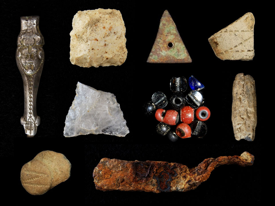
The 2011 shovel testing and test excavations at Zekiah Fort yielded a total of 7,836 artifacts.
Artifacts recovered include lithics of European flint and native stone,
Indian and European ceramics, red and white clay tobacco pipes, glass beads, bottle glass, iron
nails, lead shot, brass triangles, brass scrap, and animal bone as well as various other finds
represented in small quantities. Given the rich assemblage of artifacts, it is possible that the
portion of the site located atop the knoll represents the residence of an elite household, possibly
that of the Piscataway tayac and his family. The artifacts recovered from the area at the base of
the knoll contained fewer artifacts and few prestige items.
The collection also includes 19th- and 20th-century artifacts, albeit in
low density. These artifacts represent a later ca. 1830-1860 domestic occupation
associated with either the Thompson family or Benjamin F. Montgomery's ownership of
the property.
Surprisingly, the largest category of material recovered from the site included animal bone,
numbering 4,498 fragments (this count does not include quantities recovered from the water-screened
column samples). The sheer quantity of the faunal remains is impressive given the acidic nature of
the soil and the plowed contexts from which they came. Brad Hatch analyzed the faunal assemblage
from the 2011 excavations at Zekiah Fort, finding that it was less diverse than the assemblage recovered from
the Native-occupied Posey site on Mattawoman Creek, also in Charles County, Maryland. Wild species
predominated at Zekiah Fort, but elements from a pig and a cow were recovered and may represent animals or
foodstuffs brought in when the Piscataway were under pressure from raiding groups and in dire straits. More
than 281 oyster shell fragments were recovered from Zekiah Fort even though the site is located some 25
miles from the nearest oyster habitat. The oyster shell was highly fragmented, weighing less than 400 g or
14 ounces.
Ceramics include 906 fragments of both European and Native manufacture. Native-made ceramics predominate
at 721 fragments and include Moyaone, Potomac Creek, Townsend, Yeocomico, Camden, colonoware, and unidentified
shell-, sand-, and grit-tempered types. European ceramics include Rhenish and English brown stoneware,
Staffordshire slipware, Manganese Mottled earthenware, Borderware, Buckley-like earthenware, North Devon
gravel-tempered ware, tin-glazed earthenware, Merida Micaceous earthenware, and unidentified earthenwares.
Merida Micaceous, an unglazed Spanish ceramic, forms approximately one-third of the colonial European assemblage.
Tobacco pipes number 926 fragments, including red (n=263) and white (n=661) pipes. One tobacco pipe remains
unidentified and one appears to be agatized although not a Bookbinder variety.
Lithic artifacts include primarily European flint flakes, shatter, and gunflints; 26 gunflints were recovered
from Zekiah Fort and all but one are made from European flint. The exception is a gunflint made from what
appears to be a non-local American chert. None of the more than 500 European flint fragments appear to
represent a form other than debitage or a gunflint. Other lithic artifacts found in the assemblage include
tools, flakes or debitage, and fire-cracked rock of quartz, quartzite, and other native stone. Overall, the
lack of native stone artifacts suggests two things: little if any Native occupation before 1680 and, after
1680, an increasing reliance on European guns for defense and subsistence.
 Glass bead, Zekiah Fort (St. Mary's College of Maryland)
A total of 463 glass beads are included in the Zekiah Fort collection (not including column sample beads),
forming one of the largest glass bead assemblages from any site in Maryland, especially one occupied for such
a brief period. The majority of the glass beads are black or red in color.
A total of 483 nails are found in the collection. All of the identifiable nails are wrought with 28 complete
examples measuring from one inch to 2.3-inches in length, with an average of 1.8 inches. The relatively short
size of the nails indicates that they were not used for heavy framing but perhaps for the construction of
boxes. Some nails show signs of clinching – that is, their ends were bent or curled around – and were likely
used as fasteners.
Other artifacts recovered from Zekiah Fort include bottle glass, glass and copper buttons, copper triangles,
a copper alloy tinkling cone, copper alloy tacks, a gun trigger, a fossilized shark's tooth, an iron triangle,
lead shot, a possible lead net-sinker, a silver sword belt hook, an iron hinge, and an iron knife blade fragment.
References
Cissna, Paul Byron. 1986. The Piscataway Indians of Southern Maryland: An Ethnohistory from
Pre-European Contact to the Present. Unpublished Ph.D. dissertation, Department of Anthropology, The American
University, Washington, D.C.
Flick, Alex J., Skylar A. Bauer, Scott M. Strickland, D. Brad Hatch, and Julia A. King. 2012.
"…a place now known until them:" The Search for Zekiah Fort.
St. Mary's City, St. Mary's College of Maryland.
Hall, Valerie M.J. 2012. These Pots Do Talk: Seventeenth-Century Indigenous Women's
Influence on Transculturation in the Chesapeake Region. Unpublished M.A. thesis, Department of Sociology and
Anthropology, Illinois State University.
Marye, William B. 1935. Piscattaway. Maryland Historical Magazine 30(3):183-239.
Reynolds, Elmer R. 1883. Memoir on the Pre-Columbian Shell Mounds at Newburg, Maryland
and the Aboriginal Shell-fields of the Potomac and Wicomico Rivers. Compte-Rendu du Congrès International
Des América-nistes. 5th Session, Copenhagen. Available online at
www.archive.org/stream/proceedingsinter1883inte#page/310/mate/2p.
Rice, James D. 2009. Nature and History in the Potomac Country: From Hunter-Gatherers
to the Age of Jefferson. Baltimore: Johns Hopkins University Press.
Rice, James D. 2012. Tales from a Revolution; Bacon's Rebellion and the Transformation of
Early America. New York: Oxford University Press.
What You Need To Know To Use This Collection
- The Zekiah Fort was occupied c. 16801-692.
- The fort was built by Piscataways under siege from northern Indigenous groups.
- Archaeological investigations include 1,362 shovel tests and 71 5-by-5-foot units
- All soils were screened through 1/4-inch mesh. A cubic-foot sample of plow zone was water-screened
after screening through 1/4-inch mesh.
Further Information About the Collection
The Zekiah Fort collection is owned by the State of Maryland and presently curated by the Maryland Archaeological
Conservation Lab. For more information about the collection and collection access, contact Rebecca Morehouse,
Curator of State Collections, at 410-586-8583; email
rebecca.morehouse@maryland.gov.
To Download Data
Data and a variety of other resources from this site are available for download. To download data,
please go to the Downloads page.