Harmony Hall (18PR305)
Introduction
The Harmony Hall site (18PR305) is a late 17th- to mid-18th-century domestic site located on a
ridge overlooking the Potomac River and the mouth of Broad Creek in Prince George's
County, Maryland. The site, which is adjacent to a late 18th-century brick Georgian
house of the same name, was identified in 1985 when a pre-construction archaeological
survey was undertaken in advance of modernizing the standing structure.
The tract on which the site sits was first surveyed in 1662 for 500 acres and was
known as Battersea; the patent for Battersea, however, was not issued until 1668 to
Richard Fowke. The property was later sold in 1688 to Richard Iles and Phillip Mason.
In 1692, Mason sold his half (250 acres), including the property on which the site is
located, to Thomas Lewis. In 1696, Lewis willed 100 acres to his eldest son, Richard,
noting that Thomas's wife, Katherine, lived on the property. Richard was 11 years old
at the time. Katherine was remarried by 1697 and dead by 1698. Richard Lewis inherited
the property and, in 1709, sold it to William Tyler.
Thomas and Katherine Lewis had four children in addition to Richard, including Anne,
John, Thomas, and Margaret, all minor children at their mother's death in 1698. Thomas's
inventory lists no servants or slaves at his death. The inventory was relatively modest,
listing 24 pigs, 14 cattle, three horses, 17 sheep, some kitchen equipment, two beds and
a "prcell of old Carpenters Tools." Thomas was just 31 years old at his death; had he lived,
chances are he would have accumulated more wealth. Circumstances changed for the Lewis heirs
who likely remained at the property because, in 1707, Richard was accused of fathering a
child with his female servant.
William Tyler owned the property from 1709 until his death in 1721. Tyler was listed as a
carpenter and also owned a mill and another parcel known as Clarkson's Purchase. His widow
married Henry Massey and probably moved to Massey's plantation.
Documentary evidence suggests that, after Elizabeth Tyler left Battersea for her new husband's
plantation, the site remained unoccupied until the 1770s, when the standing brick structure
known as Harmony Hall was built. The archaeological evidence recovered from the site supports
the site's occupation between 1692 and 1721, indicating that at least two households (Lewis and Tyler)
occupied the site consecutively.
Archaeological Investigations
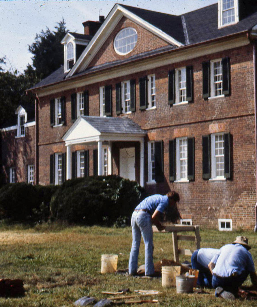 Facade with excavators
Archaeological excavations were undertaken at Harmony Hall between 1985 and 1987 by the National
Park Service under the direction of Stephen R. Potter. A total of 49 5–by-5 foot units were
excavated on the property in three areas; one of those areas, located just south of the standing
brick Georgian house, contained 17th- and early 18th-century materials. A block of 20 5-by-5-foot
excavation units was excavated in this vicinity in an effort to more fully document the earlier
component. Soil from all the units was screened through ¼-inch mesh and all artifacts were
retained. Stratigraphy at the site includes a modern topsoil and 1930s-era occupation overlying a
19th- to early 20th-century plow zone. A transitional zone from plow zone to subsoil was also
observed in the units. These five strata, which covered the entire site, are described in the
report but the artifacts from them, which have not been catalogued, are not included in the database at this time.
Feature 14 was identified as a shallow basin-shaped refuse pit that appears to have been filled in
rapidly late in the site's occupation based on a mean ceramic date of 1729.
Feature 17 was identified as a large, late 17th- to early 18th-century borrow pit. Initially,
archaeologists thought that Feature 17 was a cellar or other architectural feature due to its
large size, roughly straight and parallel edges, the presence of charred wooden members, and
an associated post hole and mold. Upon excavation, Feature 17 revealed an irregular bottom,
indicating that the feature was a relatively shallow borrow pit excavated to secure clay for
making daub or brick. Feature 17 contained two additional features, including Features 63 and 64.
Feature 64 was initially interpreted as a hearth with a roughly square shape and fill containing
an abundance of charcoal, ash, daub, and soft brick. Ultimately, the excavators determined that
Feature 17 was initially dug as a clay source and that the feature was filled with
the burned debris of an earthfast building. Given that both the documentary record and the
artifacts from the site indicate an initial occupation date of 1692, it is unclear when Feature
17 would have been initially dug. The size of the feature suggests that it was dug for a large
amount of clay, an action typically associated with a site's beginning date of occupation. The
artifacts contain dipped white salt-glazed and white salt-glazed stoneware (along with a few
fragments of pearlware and whiteware, presumably intrusive), suggesting a fill date no earlier
than 1720.
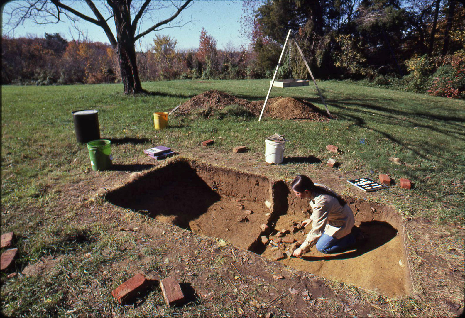 Feature 14
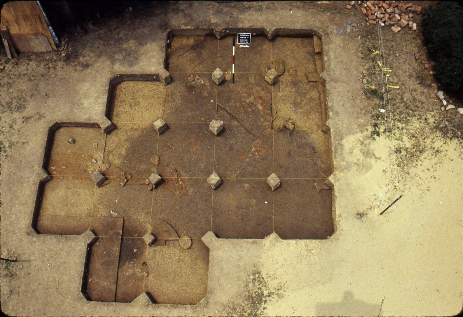 Feature 17, plan view
Feature 22 was a small refuse pit consisting of three distinct levels of fill. Artifacts recovered
from the pit suggest that the pit was filled rapidly late in the site's occupation. Although not
discussed in the report, Feature 22 may have been initially excavated for clay to repair a daub
chimney associated with the late 17th-century house, especially since this house was approximately
30 years old when the pit was filled.
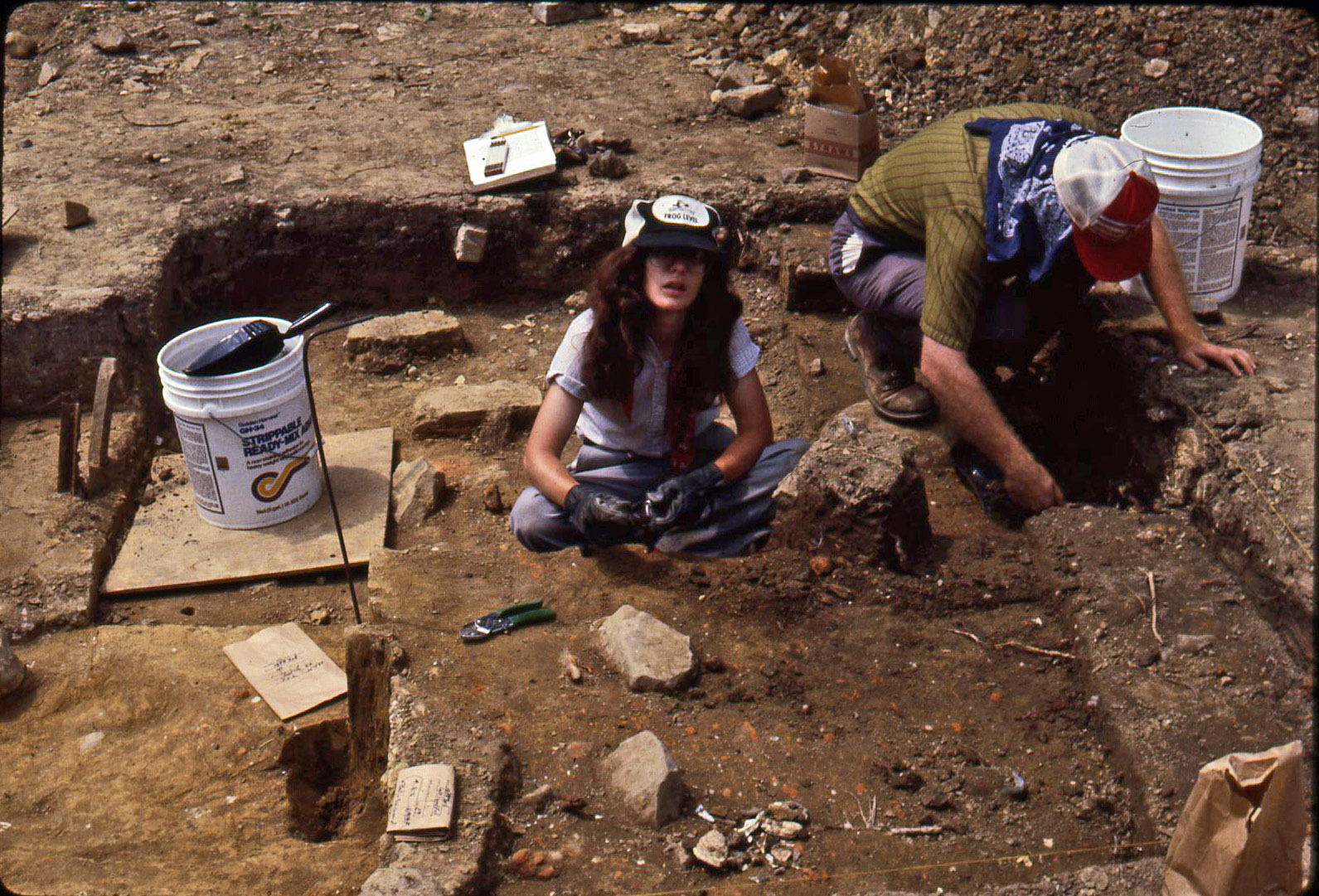 Matt Virta and Nancy Chabot
Feature 24 was identified as a brick clamp that was not fully excavated. No diagnostic artifacts
were recovered during the testing, although the archaeologists believe that the clamp is associated
with the brick Georgian house and not the site's early colonial component.
Features 41 and 41A were a post hole and mold (A) for an earthfast structure. The feature was
typical of post holes and molds associated with the construction of pre-assembled reverse
assembly post-in-ground buildings, with a large mold located at one end of a stepped post hole.
No artifacts were recovered from the post hole, suggesting traces of a building erected soon after
the property was acquired by Thomas Lewis.
Feature 48, which is included in the database, was interpreted as a ca. 1780 or later deposit
associated with the brick Georgian house. The feature is, however, located in the vicinity of
where the excavators project the southwest corner of the late 17th-century earthfast structure.
Artifacts
The artifacts in the database number 4,955 objects and include materials recovered
from feature contexts only, including Features 14, 17, 22, and 48 (Features 41 and 41A, the post
hole and post mold, did not include any artifacts). Not included are artifacts from the overlying
five strata.
Domestic materials recovered include 620 clay tobacco pipe fragments, 595 ceramic
fragments, 294 wine bottle glass fragments, and 362 animal bone fragments. Of the pipe fragments,
only two from the late 17th to early 18th century are decorated with rouletted pipe bowl rims.
Ceramics include ware types expected for this period, notably tin-glazed earthenware, North
Devon gravel-tempered ware, Buckley earthenware, Staffordshire slipware, Rhenish blue and gray
stoneware, English brown stoneware, dipped white salt-glazed stoneware, and white salt-glazed
stoneware. Pearlware, whiteware, and Rockingham ware are associated with the later occupation
of the property.
Architectural artifacts include 201 brick fragments, 967 iron nails (not all wrought), 4
iron hinge fragments, and 3 window leads.
Small finds include 9 glass beads, three buckles, three gunflints, two copper alloy straight pins,
two buttons, one button, one iron hoe, one iron ladle, one pair iron scissors, and one iron lock.
Only 325 of the 1,424 recovered animal bone fragments were identifiable (the total reported exceeds
the numbers reported for the features included in the database). Cow, pig, sheep, chicken, deer,
goose, duck, teal, catfish, snapping turtle, and box turtle comprised the food species; bones
from a dog were also identified. Beef and pork constituted the greatest consumed meats, forming
nearly 93 percent of the meat weight in the faunal assemblage.
References
Sonderman, Robert C., Matthew R. Virta, Marilyn W. Nickels, and Stephen R.
Potter. 1993. Archaeology at Harmony Hall: Exploring the
Late Seventeenth-Century Frontier of
Maryland. Occasional Report No. 9, Regional Archeology Program. Washington, D.C.: National Park
Service-National Capital Region.
What You Need To Know To Use This Collection
- Soils were screened through 1/4-inch mesh.
- Only feature artifacts are included in the database.
- The artifacts in the database come from inventories found in the report.
- Small finds were reexamined and documented as part of this project.
Further Information About the Collection
The Battersea/Harmony Hall (18PR305) collection is owned by United States and
curated by the National Park Service. For more information about the collection
and collection access, contact the Collections Manager, Museum Resource Center
at 301-832-3969; email Karen_Orrence@nps.gov.
To Download Data
Data and a variety of other resources from this site are available for download. To download data,
please go to the Downloads page.