Addison Plantation (18PR175)
Introduction
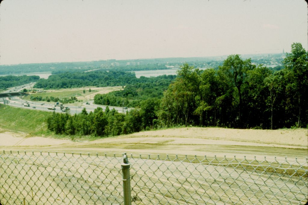 Hilltop view, Addison Plantation (MAC Lab Catalog Number pr175a- 00784s)
Addison Plantation (ca. 1695-1727) is the name given to the earliest known colonial settlement
at what is today called Oxon Hill Plantation (18PR175). Addison Plantation was situated on a
bluff overlooking the Potomac River in Prince George's County, Maryland, directly across the
river from present-day Alexandria, Virginia. The portion of the plantation of interest to this
project includes an earthfast structure with a large cellar accessed by a semi-subterranean
external passageway. The site was identified in 1983 by the Maryland State Highway Administration
(MDSHA) and excavated between 1986 and 1988 by John Milner Associates (JMA) in advance of
commercial and residential development. When the property's then-owner was unable to continue
excavations due to financial difficulties, JMA curated the collections until 2003, when a new
owner funded additional work with the collection and the collection was transferred to the
Maryland Archaeological Conservation Laboratory. In 2013, St. Mary's College of Maryland
undertook the cataloging of material from the site's early colonial component, including
features associated with the earthfast structure.
Addison Plantation was the home of one of the most powerful planter-merchant families in colonial
Prince George's County. Colonel John Addison had come to Maryland from England in 1674. In 1677,
Addison married Rebecca Dent, a widow with six children, and the couple had another son, Thomas,
born in 1679. By 1687, Addison had moved into what was at the time upper Charles County. In 1692,
Addison purchased the patent to the St. Elizabeth's tract several miles downriver from the mouth
of the Anacostia. This tract would become the site of Addison Plantation/Oxon Hill Manor.
St. Elizabeth's had been settled first by John Charman, who eventually conveyed it to John Meekes.
Meekes does not appear to have lived at St. Elizabeth's, but he had a tenant there before Addison
obtained the patent. This tenant was Captain James Conoway, a merchant-mariner who would later
determine a portion of the Maryland-Pennsylvania boundary for William Penn and Charles Calvert.
It is possible but not likely that Conoway built the earthfast dwelling that was excavated in
the 1980s. More likely (given the artifact dates), John Addison was the builder.
John Addison was a planter, merchant, and Indian trader whose ship, Liverpool Merchant, was
seized in 1679 for violating the English Navigation Acts. Addison was elected a justice for
Charles County in 1687 and supported the Protestant Rebellion that took place in Maryland
in the summer of 1689. From 1689 until his death in 1705, Addison served first as a captain
and then as a colonel in the colonial militia. From 1692 until 1705, he also served on the
Maryland Council, the political body that advised the governor. At his death in 1705, Addison
owned 6,478 acres and had a total estate value of 1,840 pounds, including one servant and
fourteen slaves. A probate inventory,
taken in 1709, survives for John Addison.
Addison's son, Thomas, inherited his father's property in 1705 or 1706 and had begun construction
on a new house nearby by 1710 or 1711. Archaeological evidence and Thomas Addison's 1727 estate
inventory suggest that the earlier earthfast house remained standing and may have been used as a store
before its destruction by fire soon thereafter.
Thomas Addison's 1727 inventory lists
a building described as "The Other Store." This space included
many yards of fabric, architectural materials such as padlocks, nails, and hinges, tools including
hoes, axes, and files, and arms-related materials, including gunpowder, shot, and a pair
of "Pistolls Damaged." The relatively large number of arms-related artifacts recovered from
the cellar of the earthfast house led investigators in the 1980s to suggest that, by 1727, this
building may have functioned as "the other store."
Archaeological Investigations
Terrence W. Epperson first identified Oxon Hill Manor (18PR175) in 1980 as part of the initial
planning process for reconstructing the Maryland Route 210/Interstate 95 interchange. Richard
J. Dent directed an additional Phase I survey of the site in 1981, recommending a realignment
of the planned highway construction to avoid the archaeological site. In 1983 and 1984, Silas
Hurry conducted excavations in the proposed new alignment. Hurry was able to define
five activity areas which he designated Areas I through V. Area V centered on a small earthen
mound and an adjacent depression and would later be found to include the earthfast structure
and associated deposits that are described in this finding aid.
In 1985, Garrow and Associates, Inc. undertook additional investigations on the property. This
work focused on Areas I through VI and included the excavation of 11 screened and 14 unscreened
one-by-one-meter test units in Area V. This work revealed evidence for what was probably an
18th-century meathouse. The artifacts suggested that Area V had been used throughout the
plantation's history, and at least one structure was non-residential in purpose.
In 1986, JMA began its work in Area V. Their initial excavations were internally called
"Addison I" and included eight test units, exposing a portion of a cellar. JMA redefined
Area V to include Areas V, Va, Vb, and Vc. Their work uncovered an earthfast structure
represented by a collection of post molds and holes, the aforementioned cellar, and a
lengthy and partially subterranean passageway leading into the cellar. The artifacts
recovered from this area suggested an early structure or structures associated with Addison
plantation. JMA interpreted the earthfast structure with its cellar as a dwelling that was
later converted into a storage facility ("the other store") for Thomas Addison and also as
a militia armory and a locus for militia activity on the Potomac frontier. JMA's work found
that the compound had been destroyed by fire not too long after Thomas Addison's probate
inventory was recorded in 1727.
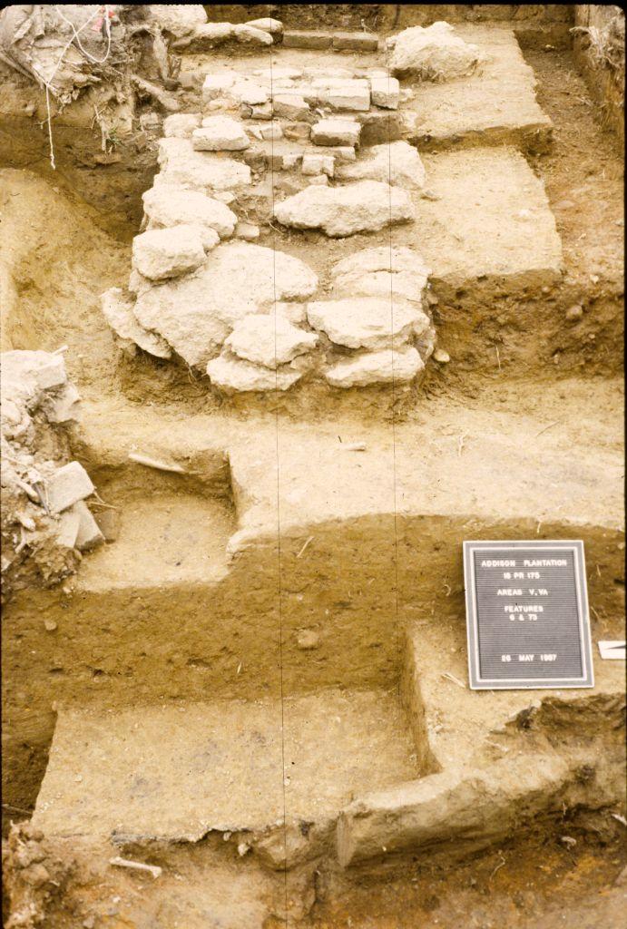
Features
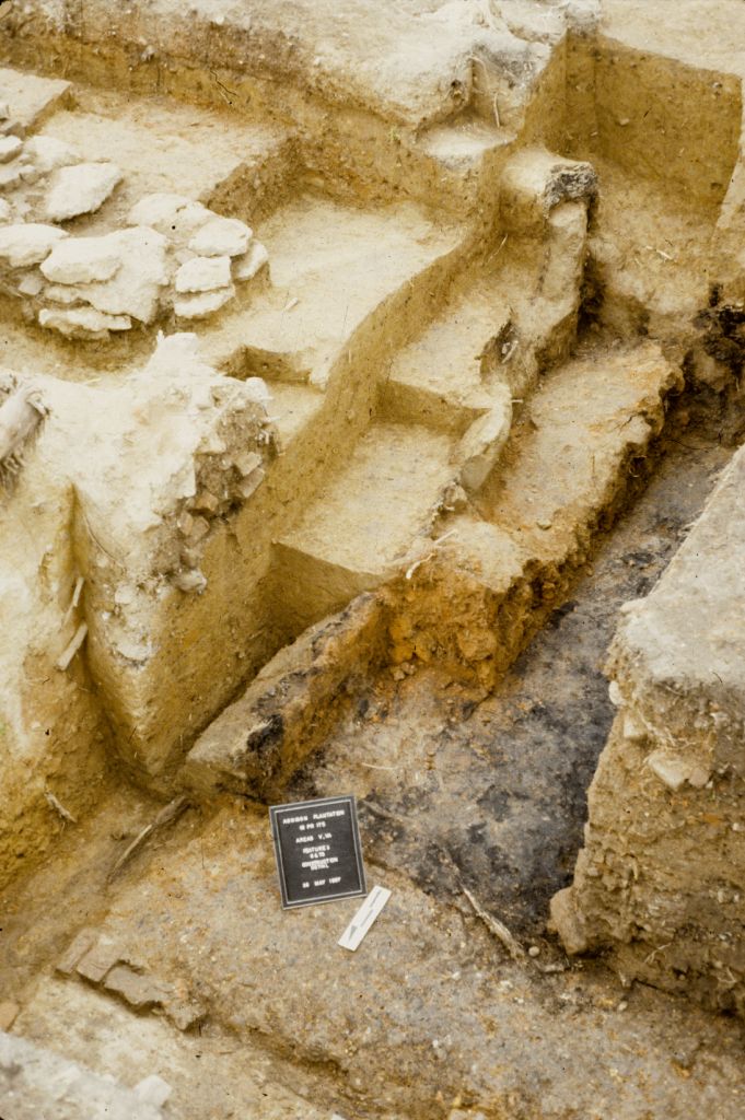
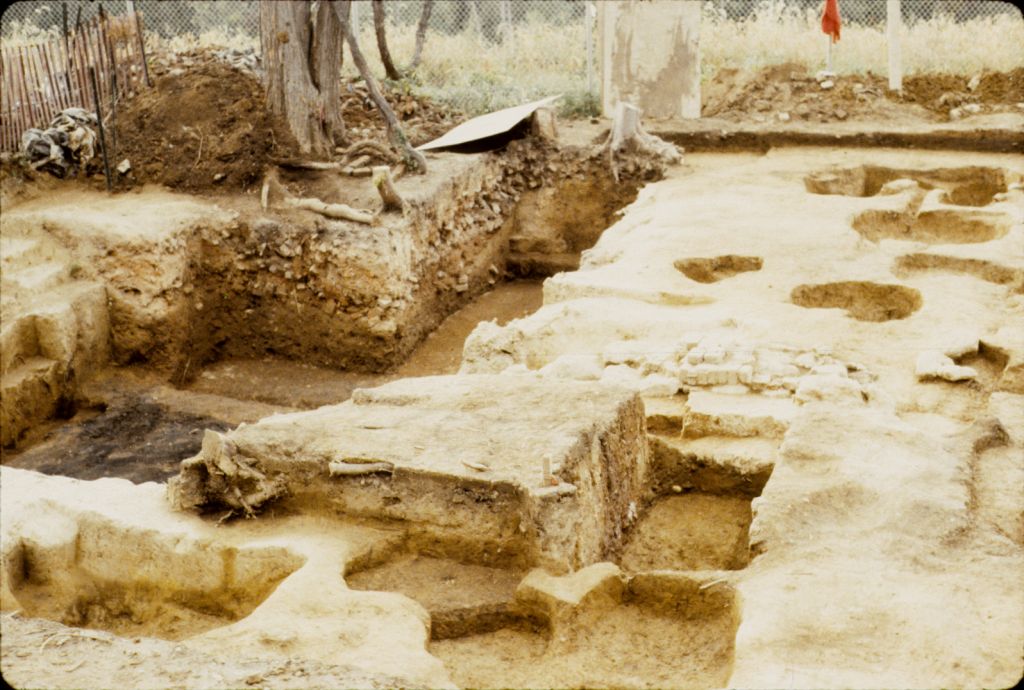 Overview of the cellar (Feature 6) and adjacent features (MAC Lab Catalog Number pr175a-03367s)
Over 180 features were identified in Areas V, Va, Vb, and Vc; some of these features were
excavated while others were only mapped, making it challenging to sort out their relationships.
The major features included the earthfast structure, the cellar (Feature 6), and the subterranean
passageway (Feature 329).
The cellar (Feature 6) was found in the west half of the earthfast structure. It measured
approximately 14 by 28 feet and was excavated 6 feet below historic grade. The cellar had a
partition wall that separated the main area from a smaller room with a paved brick floor
(with no mortar) lying over sand; this smaller room was considered a potential "cider room"
by JMA fieldworkers. Field notes and photographs indicated that the cellar floor showed
impressions of barrels and English brown stoneware jugs stored or left in position when
the roof and walls collapsed.
Only the walls along the southwest, south, east, and a portion of the northeast corner of
the cellar were exposed. The south walls were probably plank lined, but no sill features
were present. Instead, there may have been a robbed brick foundation, owing to a very large
builder's trench. The original floor was probably earthen, with any wood planks having fallen
from the first floor above.
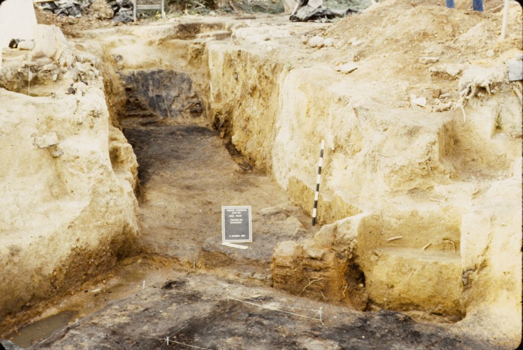 View towards subterranean passageway (Feature 329) from cellar (Feature 6) (MAC
Lab Catalog Number pr175a-03242s)
View towards subterranean passageway (Feature 329) from cellar (Feature 6) (MAC
Lab Catalog Number pr175a-03242s)
Feature 329, the plank-lined semi-subterranean passageway, extended about 22 feet from the
southwest corner of the cellar. Excavators believed the passageway post-dated the construction
of the cellar. The doorway from the cellar into the passageway was 5 feet wide; the passageway
itself was roughly 6 feet wide and ran roughly 5-6 feet deep. There may have been a roof over
the passageway, based on post hole features (Features 525 and 526) found along the walls of the
passageway. Because of time constraints, only units at either end of the passageway were excavated
with full stratigraphic control. The remainder of the fill was removed as a single deposit to reach
the destruction event sediments. Similarly, the fill in the cellar, with the exception of several
"control units" in strategic areas, was removed until destruction layers were reached.
Other features included an H- or C-shaped chimney and a number of post holes, including what are
probably structural post holes and others to the south and west of the cellar. A large trash pit
was also identified to the west of the posthole complex. It is possible that at least some of
these features post-date the early occupation.
JMA archaeologists interpreted the structural post molds, chimney base, and cellar as a 50-by-30-foot
earthfast building with a central chimney. In 2014, architectural historians with The Colonial
Williamsburg Foundation examined the evidence and suggested there could be at least two buildings
within this complex of features: the first, an atypical earthfast structure rising from the cellar,
and the second, an earthfast structure immediately to the east built in a more typical 18th-century
style with two bays and an internal end chimney, creating a structure roughly 22 feet square.
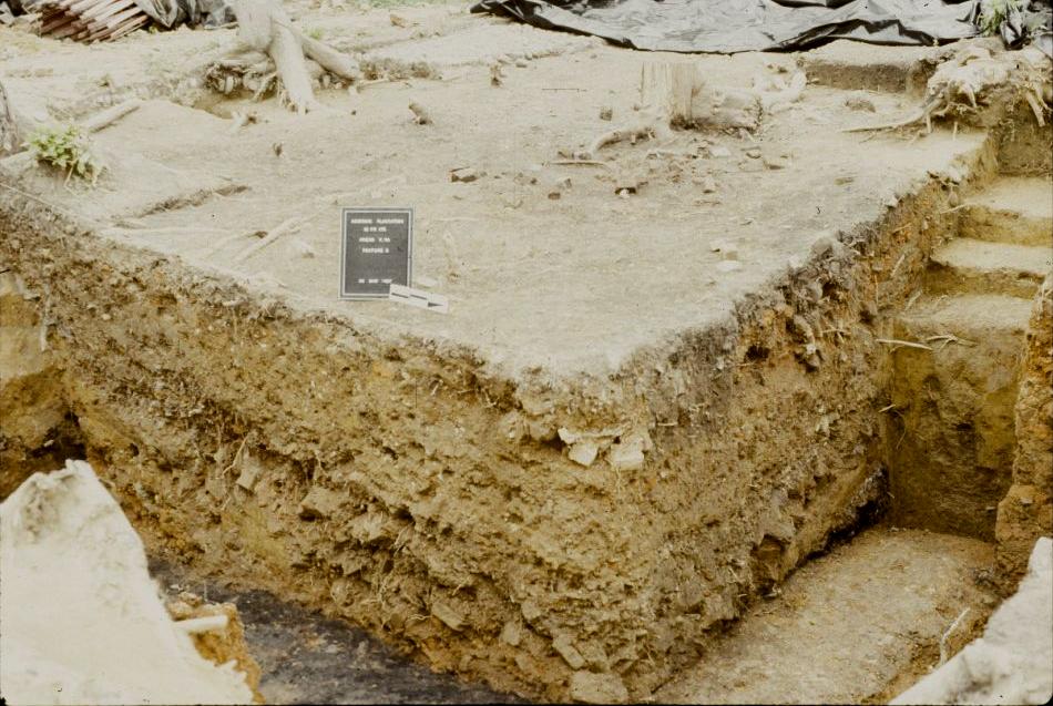 Cellar fill profile (Feature 6) (MAC Lab Catalog Number pr175a-00250s)
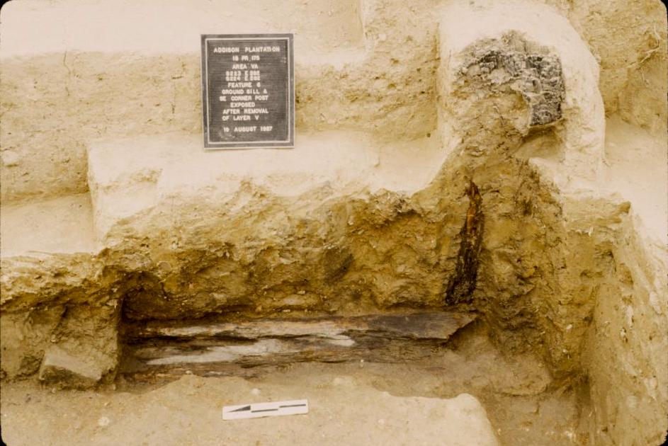 Ground sill and corner post (MAC Lab Catalog Number pr175a-01985s)
 Overview of cellar partition and chimney base (MAC Lab Catalog Number pr175a-00256s)
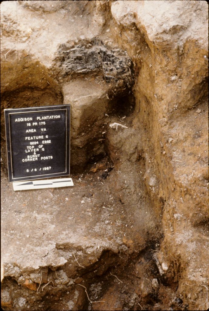 Burned posts in the cellar (MAC Lab Catalog Number pr175a-00061s)
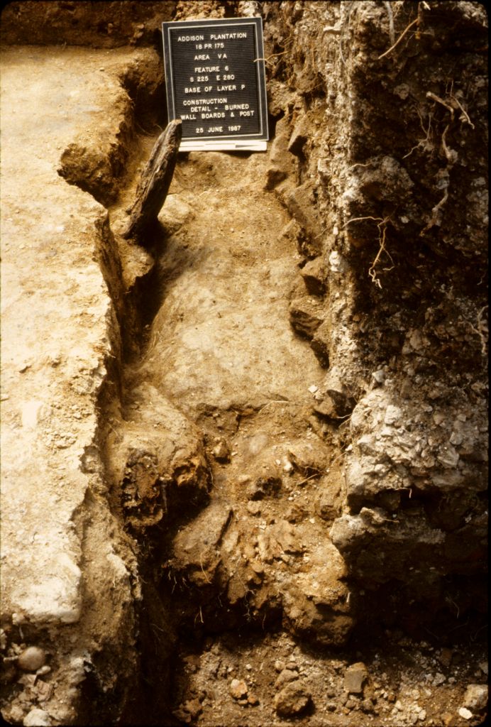 Burned wallboard in the cellar (MAC Lab Catalog Number pr175a-00825s)
 Chimney base of brick and rock (MAC Lab Catalog Number pr175a-00223s)
Artifacts
More than 72,000 artifacts were recovered from Areas V, Va, and portions of Areas Vb and Vc and
cataloged as part of the present project. The majority of artifacts came from the cellar (Feature 6)
and the passageway (Feature 329).
Artifacts recovered from the cellar and passageway contexts included architectural materials
(hinges and more than 10,000 nails), furniture hardware, a woman's sidesaddle, firearm fragments,
and a large amount of burned domestic material. Most of this material was probably the property
of Thomas Addison; almost all the wine bottle seals in the assemblage bear the initials "TA."
Addison's 1727 probate inventory indicates the space described as the "Other Store" held over
400 wine bottles, providing additional evidence to suggest that this building represented a
store repurposed from an earlier dwelling.
Several window leads were found in the cellar fill with dates of 1685, providing some support
that the earthfast dwelling dates to the late 17th-century date. A tentative Binford date of
1734 has been calculated from the measurable white clay pipe stem bore diameters. Given that
the cellar structure is believed to have burned not long after 1727, these are late dates,
but could be at least partly due to surrounding lat er activity. Additionally, at least two
known Dutch pipes were found in the cellar. The inclusion of Dutch pipes in a pipe stem dating
group can skew dates later by as much as several decades. Further, it is difficult to identify
a Dutch pipe fragment from an English pipe fragment without decorative features present, which
makes separating English pipe stems from Dutch unlikely. The presence of several Dutch pipe
fragments in the lower levels of the cellar thus indicates that dating of pipes from the cellar
may give later dates than expected.
Preliminary analysis shows that the majority of the later 18th-century artifacts appear to be
concentrated in the northeast corner of the cellar, in the direction of several 18th- and 19th-century
structures previously identified by Garrow & Associates beyond Area V. The absence of white salt-glazed
stoneware fragments in the earthfast structure's post molds suggests that activity ceased before ca. 1740.
Dipped white salt-glazed ceramics are present, and these wares can date slightly earlier than 1720.
For all the trading Colonel John Addison was alleged to have done with Natives, there were few trade
goods uncovered. One copper alloy tinkling cone, two iron jaw harps, and 13 glass beads are present
in the assemblage. Thirty-four buckles, including 6 clothing and 15 utilitarian, are also part of
the assemblage.
Arms at Addison include 8 flintlock mechanisms, 17 ramrod thimbles, 2 pistol butt plates, including
one miniature pistol, and at least 6 gunflints. Surprisingly, very little gunflint debitage was
present, and almost no lead shot (only 3 pieces). An elaborate small-sword's hilt, shells, and quillons
engraved with worldly symbols of cornucopias, globes, and figures indicate that swords were still
a part of the elite gentleman's ceremonial uniform during this period of colonial history.
References
Castle, Guy. 1965. The Washington Area between 1608 and 1708, with a Biographical
Note on Prince George of Denmark. Records of the Columbia Historical Society, Historical Society of
Washington, D.C., Vol. 63/65 pp. 1-18.
Hurry, Silas. 1984. Intensive Archeological Testing of the Oxon Hill Manor Site.
Report submitted to the Maryland State Highway Administration. Maryland Geological Survey, File
Report Number 187.
Hurry, Silas, and Maureen P. Kavanagh. 1985. Additional Intensive Archeological
Testing at the Oxon Hill Manor Site: an 18th through 19th Century Plantation in Maryland. Report
submitted to the Maryland State Highway Administration. Maryland Geological Survey, File Report
Number 189.
Garrow, Patrick H., and Thomas R. Wheaton Jr. 1986. Oxon
Hill Manor Archaeological Site Mitigation Project. Report to the Maryland State Highway Administration. Prepared by Garrow &
Associates. Atlanta, GA.
Hatch, D. Brad. 2014. A Report on the Analysis
of Faunal Remains from Addison Plantation (18PR175). Department of Anthropology, University of Tennessee, Knoxville.
McCarthy, John P. 2010. Oxon Hill Manor: The Archaeology
and History of "A World They Made Together." Jefferson Patterson Park and Museum, St. Leonard.
McCarthy, John, P., Jeffrey Snyder, and Billy Roulette. 1991. Arms from Addison
Plantation and the Maryland Militia on the Potomac Frontier. Historical Archaeology (25)1:66-79.
McCarthy, John P., Jeanne A. Ward, George D. Cress, and Charles D. Cheek. 1990.
Intensive Archaeological Survey of the Addison Plantation Site and Intensive Archaeological Testing
of the Addison Manor Foundations, Beltway Parcel, Port America Development, Oxon Hill, Prince Georges
County, Maryland. Report for James T. Lewis Enterprises, Ltd., Alexandria, VA. John Milner Associates,
West Chester, PA.
Rimer, Esther. 2014. A Preliminary Artifact Analysis from the Earthfast Structure
at Addison Plantation. Paper given at the 71st annual Southeastern Archaeology Conference, November
12-15, 2014, Greenville, SC.
Roulette, Billy. 1987. Features 6/329 Cellar-Passageway. Addison Excavation Summary
Record Field notes from Milner Phase III. December 17, 1987. Reproduced in Jefferson Patterson Park &
Museum Archaeological Collections in Maryland. Available on line at http://www.jefpat.org/NEHWeb/.
Oxon Hill Manor documents: 70975-70976.
What You Need To Know To Use This Collection
Only the materials from JMA's investigations of Areas V, Va, Vb, and Vc in 1985 and 1986 are included
in the online catalog. At this time, materials from Hurry (1984), Hurry and Kavanagh (1985), and Garrow
and Wheaton (1986) are not included in the catalog. Researchers are directed to those reports for
additional information. Researchers are also directed to the
Oxon Hill Manor/Addison Plantation collections page maintained by the Maryland Archaeological Conservation
Laboratory for field records, maps, and other field and laboratory records.
Field records included few profiles or cross-section drawings, making it challenging to date levels in the
features, especially the cellar and passageway.
Further Information About the Collection
The Addison Plantation collection is owned by the State of Maryland and curated by the Maryland Archaeological
Conservation Laboratory. For more information about the collection and collection access, contact Rebecca
Morehouse, Collections Manager, at 410-586-8583; email rebecca.morehouse@maryland.gov.
To Download Data
Data and a variety of other resources from this site are available for download. To download data,
please go to the Downloads page.